Excellent description of what is going on
Colette said...
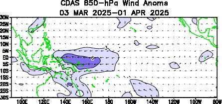
During La Nina a surface low pressure develops over the region of Northern Australia and Indo and a high pressure system in the east over the coast of Peru, so the easterly trades over the Pacific are strong (compoared to during El Nino). So the warm surface water current moving from east to west is strong, meaning warmer water to northern Australia...so more rain (convective stroms formation)... So yeah, trades in FNQ should be stronger...unless the increased storm action kills them near the coast.
But this warm water goes south in the East Australia Current and warmer water around Sth East Qlds means less of a sea land temperature gradient so less sea breezes... I think most of the wind they've had this season has been frontal...rather than sea breezes.