Hi JonE,
When I saw nobody else had chipped in after a few days of your post, I dashed off an email about it to Ports Victoria. Then I quickly forgot all about it.
Surprise, surprise - 14 days later a reply came in. Below is the essence of the email exchange:-
Me to Nav Services (Ports Victoria):-
. a recreational yacht owner has a query about an area outside the heads surrounding the Pilot Boarding Ground centre point.
He is interested in seeing some written words about how this area is defined, (eg NtoM details) and what, if any, restrictions there are for crossing that area for recreational yachts with no shipping in sight.
The area seems to be first referenced in HMD 13.1 (Sept 2023) and is named as the "Pilot boarding ground (PBG) Precautionary Area". It shows up on his chart as a 3nm diameter circle centred on the PBG, but with no other notes as to its purpose or operation.
In some ORCV post-2023 sailing instructions for their ocean races, they declare a "no-go zone" there, but as a diamond shape around the PBG with the N,E,S,W apexes 1.5 nm from the PBG centre point.
[Note added 18/6/2026:- I see that for ORCV's recent 2026 Apollo Bay race, the above no-go diamond has become an octagon (poor man's circle?). You are also required to take a pic of your chart plotter that demonstrates your track did not cross the no-go zone.]He is interested in any clarification you can provide.
Many Thanks,
--------------------------------------------
Navigational Services response:-
18 Jun 2026 01:49:35 +0000
Good morning, xxxx
The Pilot Boarding Ground Precautionary Area is defined on the relevant official paper chart AUS 143 and electronic navigational chart (ENC) AU439144 off Port Phillip Heads - screenshot as per below.
The text detailed on the Precautionary Area states as follows:
PRECAUTIONARY AREA
Traffic within the Precautionary Area consists of vessels manoeuvring on various courses for the purpose of embarking or disembarking Pilots.
Vessels should not approach or enter the Precautionary Area unless permitted by Lonsdale Vessel Traffic Service (VTS).
Mariners are advised to navigate with caution in the vicinity of the Precautionary Area.
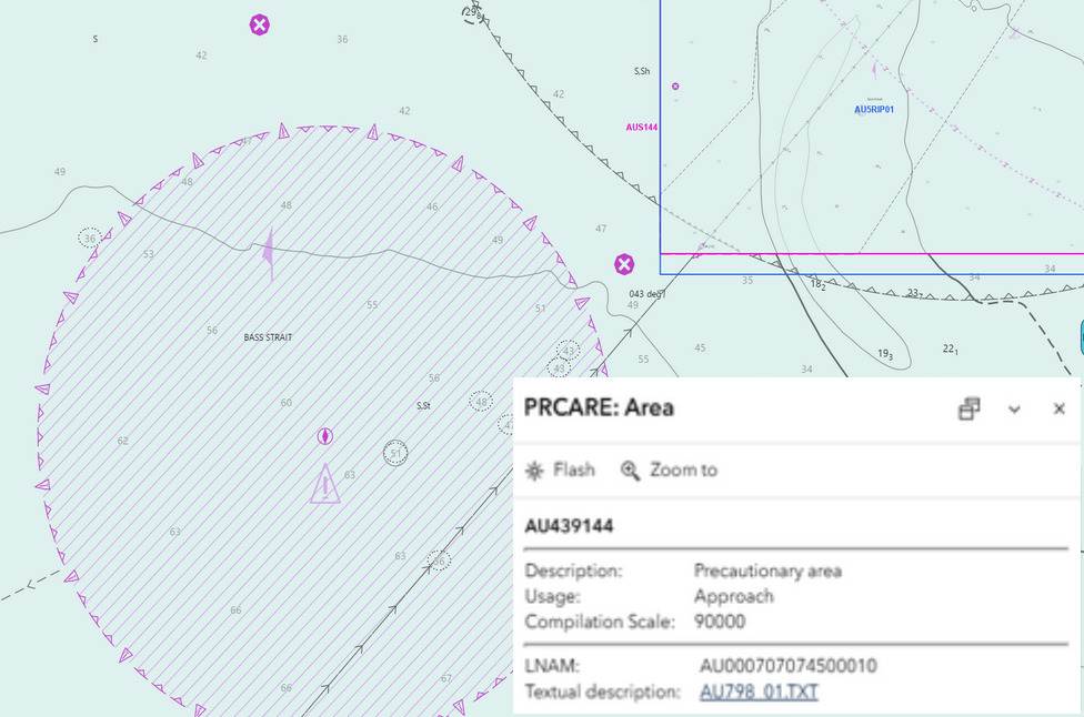
[Note: JakeH has enlarged text insert for better readability. That insert didn't come up I my freebie eChart, but presumably would have on the paid premium version. I got no sensible hits on the named text file in a Google search.]
Nav Services advice continues:
In terms of entering the PBG precautionary area, yachts and other vessels may do so provided no ships are within the precautionary area or are expected to be within the area defined above for the purposes of embarking/disembarking a Pilot.
I recommend contacting Lonsdale VTS on VHF Channel 12 to check the current state of shipping movements to/from the PBG precautionary area, before approaching the area in question in the interests of vessel safety.
If you require any further clarification, please let me know.
Kind regards,
Roland Fonseca?
Navigation Services Officer
My take:
Casual Cruising:- No issue crossing that area if no shipping about. However the mark I eyeball can't easily distinguish between ships slowly lurking well out to sea (waiting for a tide window for PPH), from those about to climb fully over the horizon whilst steaming full tilt for the PBG.
Best to use AIS, or put in a VHF call to the VTS folks to check the destination of any traffic you see (or outbound ships you can't see behind the Pt Nepean high ground).
Racing: The sailing instructions for the race might prohibit entry. If they don't, AND no ships heading there, AND you are leading the fleet, then perhaps still best not to cross that circle!
cheers,
