Are they still called Cyclones in June.?

> 10 years ago
Reply
Register to post, see what you've read, and subscribe to topics.
gumballs
gumballs
NSW
408 posts
NSW, 408 posts
7 Jun 2012 3:17pm
Just looking at the 7 day forcast and it looks like theres real potential for a cyclone to develope as of Sunday arvo.Does anyone remember this happening in years gon byImagion noosa pumping in the middle of June and the whole east coast with E/NE swell and winter westerlys to groom it.
Ted the Kiwi
Ted the Kiwi
NSW
14256 posts
NSW, 14256 posts
7 Jun 2012 3:37pm
in June we call them East Coast Lows....TC's technically need a water temp in excess of 26.5 degrees to form - although they can still power though water temps below this once they have formed. On the east coast they normally become heavy rain depressions as they travel southwards into colder water. Thats why TC's do not come too far down the coast of NSW..... ECL's are intense low pressure systems. Usually occur when the land / sea surface temp is great than 6 degrees and when there is favourable conditions in the upper atmosphere. Once conditions are ripe for an ECL its not uncommon to get several in a row. The Pasha Bulka ECL in 07 was the last in a series of them as an example.

Just found this on the BOM website for you

What is the difference between an East Coast Low and a Tropical Cyclone.

Tropical Cyclones develop over very warm tropical waters where the sea surface temperature is greater than 26°C. They have relatively long life cycles, typically about a week, and severe tropical cyclones (category 3 or greater) can produce significant property damage with wind speeds over 180km/h near the centre, heavy rainfall and coastal inundation through storm surge. Tropical Cyclone "Justin", which affected the Queensland Region in March 1997, lasted for 18 days!

East Coast Lows generally have much shorter lifetimes than Tropical Cyclones and last only a few days. They develop over the Tasman Sea close to the NSW coast and can intensify rapidly in the overnight period. Unlike Tropical Cyclones, where the warm seas provide the energy source, East Coast Lows are driven by the temperature gradient between the Tasman Sea air and cold air in the high levels of the atmosphere over the continent. They can produce gale to storm-force winds, very heavy rainfall and in some cases coastal inundation. While maximum wind speeds recorded are lower than in severe tropical cyclones, a gust of 165 km/h was recorded at Newcastle associated with the east coast low that sunk the bulk carrier Sygna in 1974. During the first of the ECLs in June 2007, when the bulk carrier Pasha Bulker ran aground, gusts of 105 km/h at 6:21am on 8 June and 124 km/hr at 1:32am on 9 June were recorded at Newcastle.
surfershaneA
surfershaneA
869 posts
869 posts
7 Jun 2012 4:45pm
I got caught on my yacht anchored in a not so protected cove during the 05/06/12 East Coast low. If I would have realised how exposed the place was there is no way I would have been there. Unfortunately, the cruiser's bible states "strong westerlies make the cove untenable". It should have read "keep the f#ck out of there in an intense southerly blow".

The first gusts from the south must have exceeded 60 knots. It literally picked my yacht up and dumped my heavy steel boat to the north sending me into moored boats. The rest of the night was a fight for survival trying not to sink the two boats I was pinned between or my own boat. That was the first time I have ever seen spume across a harbour.

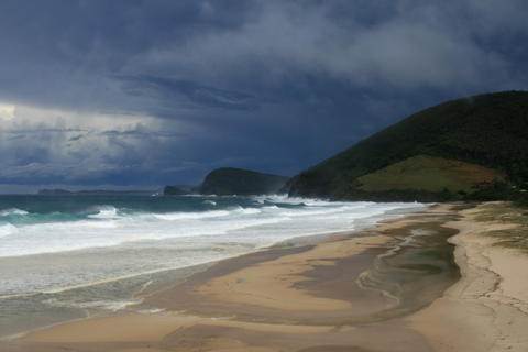
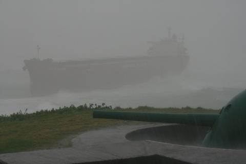
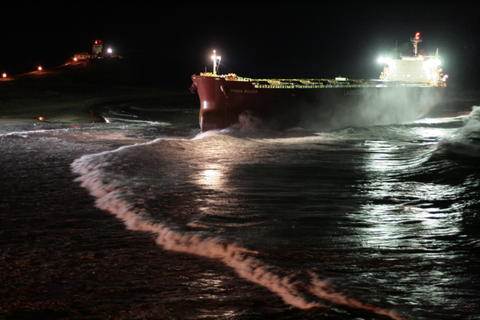
While I lived 500 metres away from where the Pashs Bulker grounded, I was driving back from the North Coast when it happened not making Newcastle till 4 pm. I took the first photo from Blueys Beach north of Seal Rocks about the time the Pasha went ashore. That is one evil storm to the south. The next is the result when I got home.

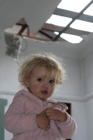
The winds the night of the Pasha storm were as bad as the morning. Along with extreme flash flooding, as in the photo, the roof blew off the house at the end of the street and landed on our cars. The same house at the end of the street pictured with my daughter also had its windward wall stove in by the winds.

My advice is to never underestimate the winter East Coast lows. The one a few days back looked like a pimple on the weather map. Yet it hit like a cyclone.


All photos by me.


gumballs
gumballs
NSW
408 posts
NSW, 408 posts
7 Jun 2012 8:29pm
Yeh I was kind'a going for dramatic effect when I said cyclone...But....It is predicted to form up off the sunny coast and the forcast I was looking at is so far calling it to drop to the mid 800hkp which is pretty low presure.Anyway Im an optimist and I would love a big winter NE swell to play with.
gumballs
gumballs
NSW
408 posts
NSW, 408 posts
7 Jun 2012 8:33pm
Oh nice pics too Shane.I was part owner of a 23' Hood for a while and we got caught out a few times but nothing like what you are describing that sounds positively scary
Warddy
Warddy
QLD
77 posts
QLD, 77 posts
7 Jun 2012 8:51pm
gumballs said...

Yeh I was kind'a going for dramatic effect when I said cyclone...But....It is predicted to form up off the sunny coast and the forcast I was looking at is so far calling it to drop to the mid 800hkp which is pretty low presure.Anyway Im an optimist and I would love a big winter NE swell to play with.


I think they would only get mid 800's on Jupiter, Mid 900'S I think only occur in the
roaring forties down south, but anything below 980 is wild I think ?
gumballs
gumballs
NSW
408 posts
NSW, 408 posts
7 Jun 2012 11:06pm
Yeh sorry mid 980s I meant.
Please Register, or first...
Topics Subscribe Reply