Batten down the hatches

> 10 years ago
Reply
Register to post, see what you've read, and subscribe to topics.
CMC
CMC
QLD
3954 posts
CMC CMC
QLD, 3954 posts
31 Jan 2011 12:58pm
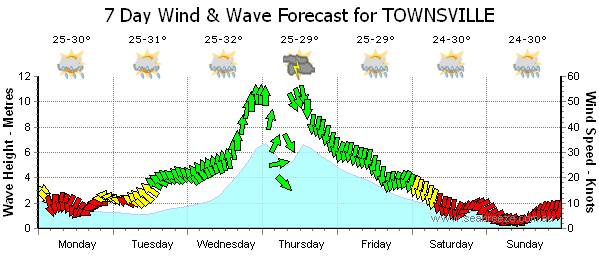
Last night TC Andrew hit Bowen. A Cat 2 not so bad, over 40 inches of rain in 24 hours though.

Now the real threat looms.

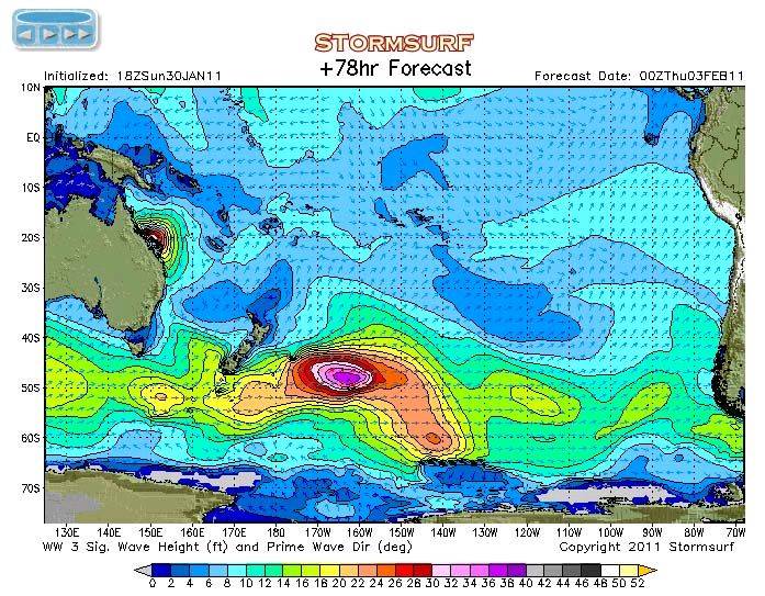
Check the screen shots below. GULP. This thing is almost as big as QLD. The Flood Relief might add a few new beneficiaries, maybe what we've seen is the entree before the main meal. Even more reason to support these charities.

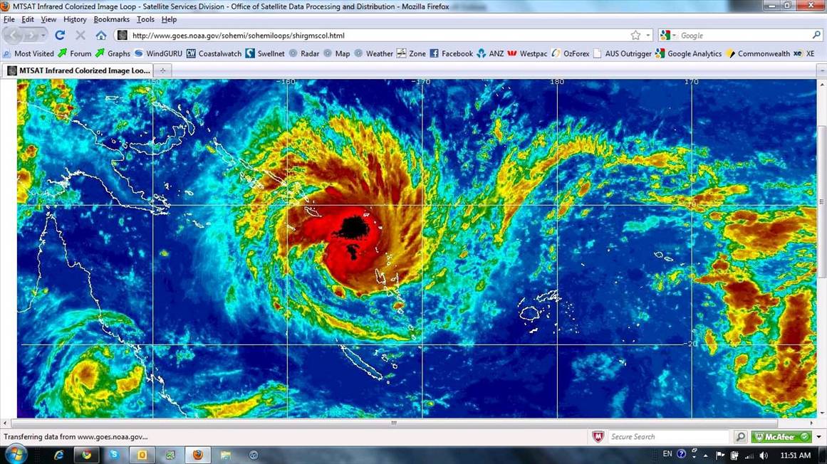
UV Shot of the system now.


Storm Surf Forecast at Thursday.


teatrea
teatrea
QLD
4177 posts
QLD, 4177 posts
31 Jan 2011 1:07pm
Geez looks like NZ is in for some bombies , or am i reading it wrong?That cyclone is huge , lets hope it stays way North.
Dazza65
Dazza65
QLD
389 posts
QLD, 389 posts
31 Jan 2011 1:13pm
Geez thats one big mother f*cker of a cyclone! Looks like the swell will hang around for a while longer.
I heard on the radio this morning this cyclone could generate 500mm of rain per hour, nows thats a worry
Simondo
Simondo
VIC
8025 posts
VIC, 8025 posts
31 Jan 2011 2:15pm
Down near NZ is a separate Southern Ocean Storm. This one shows the forecast TC path... forecast to hit QLD (at this stage).


https://www.fnmoc.navy.mil/wxmap_cgi/cgi-bin/wxmap_all.cgi?type=prod&area=ngp_tropswpac∏;=sgwvht&dtg=2011013018&set=SeaState
mikeman
mikeman
QLD
692 posts
QLD, 692 posts
31 Jan 2011 1:39pm
I have a mate on a surf trip in the Solomon Islands at the moment. It looks like they will be copping it there.
Piros
Piros
QLD
7303 posts
QLD, 7303 posts
31 Jan 2011 2:06pm
That first photo would make a good design for the seabreeze T-shirt comp.

Pretty amazing system , I've never seen anything that big hope it dies out soon if that past over New Zealand , there seriously would be nobody left their.
CMC
CMC
QLD
3954 posts
CMC CMC
QLD, 3954 posts
31 Jan 2011 2:13pm
Piros said...

That first photo would make a good design for the seabreeze T-shirt comp.

Pretty amazing system , I've never seen anything that big hope it dies out soon if that past over New Zealand , there seriously would be nobody left their.


It's still intensifying and heading directly for Townsville at this point, forecasted to cross land Wed arvo/night. Scary since TC Anthony landed 100k's or so from there just last night (Sunday).

The animation on this link shows you where it is now and how much bigger it gets.

www.stormsurfing.com/cgi/display.cgi?a=spac_height
CMC
CMC
QLD
3954 posts
CMC CMC
QLD, 3954 posts
31 Jan 2011 4:52pm
Chilling media conference.

PTWoody
PTWoody
VIC
3982 posts
VIC, 3982 posts
31 Jan 2011 5:58pm
Best wishes to all Seabreezers in the effected area.
CMC
CMC
QLD
3954 posts
CMC CMC
QLD, 3954 posts
31 Jan 2011 7:24pm
Maybe it could be the perfect downwinder:

Paddle north for a while, turn around and then come back. Only 60 knots??


Ted the Kiwi
Ted the Kiwi
NSW
14256 posts
NSW, 14256 posts
31 Jan 2011 8:59pm
Latest forecasts have it as a cat 4 which is getting pretty nasty


www.bom.gov.au/products/IDQ65002.shtml

Maybe not so good for a downwinder....here is a quick reminder of what a cat 4 can do


CATEGORY 4 (severe tropical cyclone)
Significant roofing loss and structural damage. Many caravans destroyed and blown away. Dangerous airborne debris. Widespread power failures.
A Category 4 cyclone's strongest winds are VERY DESTRUCTIVE winds with typical gusts over open flat land of 225 - 279 km/h.
These winds correspond to the highest category on the Beaufort scale, Beaufort 12 (Hurricane).
MIKO
MIKO
QLD
408 posts
QLD, 408 posts
31 Jan 2011 9:42pm
so who is coming up to go for a wave ????
Bnaccas
Bnaccas
VIC
1722 posts
VIC, 1722 posts
1 Feb 2011 12:21am
My parents sat on their balcony looking over the whitsundays when the last decent one went through, straight over the top of Airlie Beach. Winds gusted 70kts to 80kts and over 40 minute did a full 360 degree spin and blew from every direction. From memory 46 boats broke their moorings and got smashed up, some ending up in the primary school near by. 10 or 15 boats are still missing.

The current forecast makes the above event look like a gentle seabreeze! I hope people are prepared, I mean really prepared. We/Australia have had our fair share of natural disasters, it's about time we got a break!

Fingers crossed everyone stays safe.
Please Register, or first...
Topics Subscribe Reply