BWDave said...
DJ
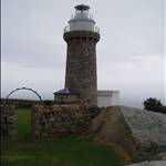
I stood on the south point of the prom about 5 months ago. The first thing that came to mind was "i'm glad I'm not paddling out there'. It is a very serious stretch of water.BTW. My photo to the left is the Prom lighthouse afew kms from South Point.
However having said that, The coast around there is outstanding and I would love to paddle with a crew from Tidal river North. Then depending on conditions we could go via Skweeky beach, Whisky bay, Shallow inlet, Sandy point, Waratah bay and Walkerville or any combination. There is great camping around the area and plenty of tasty waves too.
Oh and DJ please warn me if you are going to post such a disturbing picture as the on above.
Dave
Dave I've also looked out from the Prom and its been flat and glassy..Like a lake..So if we were lucky to pick a day like that it would be easy-peasy.
Don't worry about the great whites..They don't like firemen..

I've also heard that they don't like dish washing detergent..So I might carry some and if any come close I'll give them a squirt of my Morning Fresh..

Just read that that same green stuff can kill us..

..
www.choice.com.au/about-us/media-releases ..
I wonder what that big lake/inlet at the Prom is like?
DJ