Quixotic forum posts in last 60 days

Quixotic
Quixotic
ACT
260 posts
ACT, 260 posts
12 Oct 2026 3:00pm
Quixotic said..
<snip>
If I recall correctly ramona thinks I’m over anchored with my 22kg Sarca Excel and 10mm all chain (galvanised) rode on a 8 tonne 40 footer. But I’m happy with what I’ve got..


Turns out I've verballed ramona (apologies), it was lydia who said I was over anchored🙂
Quixotic
Quixotic
ACT
260 posts
ACT, 260 posts
12 Oct 2026 1:03pm
Kryspen said..
Settled on 8mm MUIR chain , grade 50.
Not much choice 😕 .
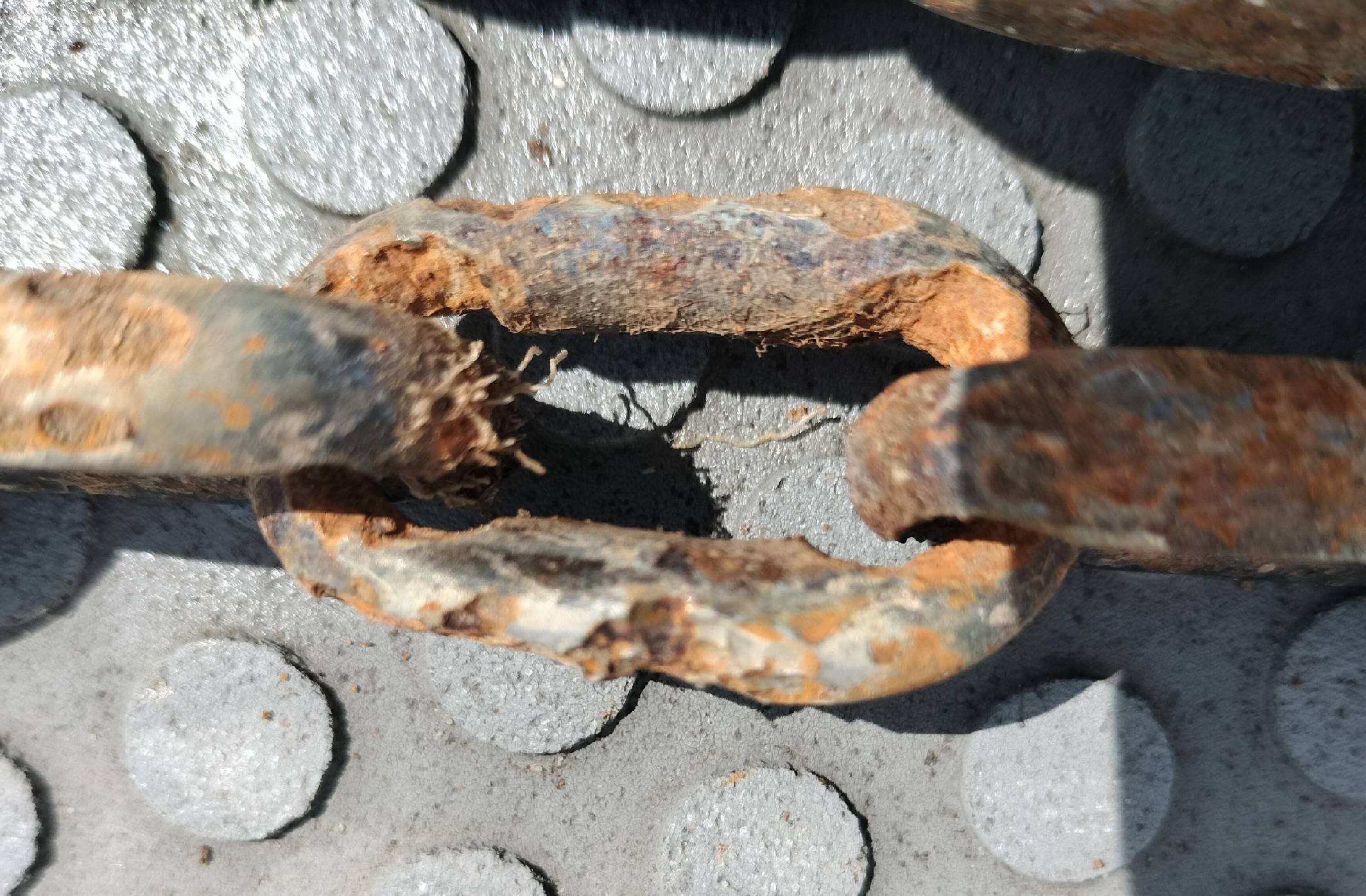
It was just in time. Pulled chain from water finding that some links are basically worn out to the max.


Out of interest, how long since that chain was new?
Quixotic
Quixotic
ACT
260 posts
ACT, 260 posts
9 Oct 2026 12:56pm
I’m sure I don’t know enough to advise others what to do. Happy to relay info that’s factual, where I have it to hand, but don’t want to step over the line to making recommendations.

Ground tackle varies according to where you want to use it and what margin you want to have amongst other things. If I recall correctly ramona thinks I’m over anchored with my 22kg Sarca Excel and 10mm all chain (galvanised) rode on a 8 tonne 40 footer. But I’m happy with what I’ve got..
Quixotic
Quixotic
ACT
260 posts
ACT, 260 posts
6 Oct 2026 6:40pm
May be cheapest to send it in a self pack 20 foot container, with the long haul bit by rail, as that's about half the price per kilometer-tonne as trucking it by road. Could work well if it's on a trailer or cradle inside the container, properly tied down / braced against any movement.
Quixotic
Quixotic
ACT
260 posts
ACT, 260 posts
6 Oct 2026 6:25pm
Kryspen said..
Previously i posted about advice on anchor chain replacement - 8mm.
<snip>
Talking to Muir about the chain i even got decent quote. But i also started looking about anchor chains on the net.
What I found ( just as well ) is that proper anchor chain, like grade L should be galvanized to Australian standards with Zink thickness at least of 75 - 89 microns minimum if anyone is using occasionally . But if someone like myself sitting on anchor 24/7 , the Zink thickness should be basically 100 microns.
I also found that chain supplier should provide manufactures certificate of the chain. The 100 microns Zink galvanized should last at least 3 years when constantly submerged in salt water .
<snip>
Well, the search is on.


Hi
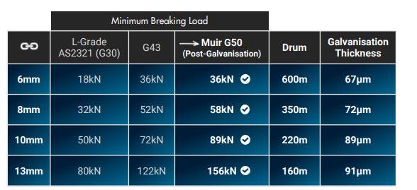
I've seen a table that suggests Muir 8mm anchor chain has zinc thickness of 72 micron (see below from marineinnovations.com.au/product/australian-short-link-grade-50-chain-8mm/ )


As I understand it, that's consistent with HDG600 which is based on grams of zinc per square metre (ie 600 per sq m) which is meant to yield a minimum local thickness of 70 microns, and an average of 85 microns.

I've heard of HDG900 which takes you to an average of 125 microns thickness.

If you want 100 microns average, then you'd need 720 g/sqm

I've not come across anchor chain that had that thickness of zinc. But then I haven't really gone looking.

There are outfits that specialise in galvanising steel as a business. They may be open to galvanising a length of G50 8mm steel chain. And they may be able to do it to 100 micron thickness.

Not sure what it would cost you.


Quixotic
Quixotic
ACT
260 posts
ACT, 260 posts
4 Oct 2026 11:19am
For those not as young as they used to be in this thread... (from: vestibular.org/article/coping-support/living-with-a-vestibular-disorder/age-related-dizziness-and-imbalance/balance-aging/ )

"The inner ear is a complex structure of fluid filled tubes and chambers. Specialized nerve endings inside these structures sense the position and movement of the head and detect the direction of gravity. Signals sent from the nerves of the vestibular system are critically important to the brain’s ability to control balance in standing and walking. They also control movements of the eyes that make it possible to see clearly while moving.

"Anatomical studies have shown that the number of nerve cells in the vestibular system decreases after about age 55. Blood flow to the inner ear also decreases with age. When the vestibular system is damaged, an individual may experience dizziness and balance problems. However, the gradual loss of vestibular nerve endings with aging can result in balance problems without any associated dizziness. This type of slow loss of vestibular function may be first noticed as difficulty walking or standing, especially in the dark while on soft or uneven surfaces (such as thick carpet or a forest path).

"A decline in balance from inner ear function may be caused by a number of conditions including normal aging, benign paroxysmal positional vertigo (BPPV), infection, Meniere’s disease, or diminished blood flow to specialized nerve cells. Additionally, certain medications such as some antibiotics for severe infections and chemotherapy may damage the inner ear, resulting in temporary or permanent hearing loss, impaired balance, and trouble seeing clearly while in motion. Feelings of dizziness, vertigo, imbalance, and disequilibrium may indicate that the inner ear is not functioning correctly."

In my totally amateur (ie unqualified) opinion, this is also complicated by a marginal loss of both strength and reaction times that decrease agility in older age.

You can offset these up to a point by doing things that require balance and leg/core strength. In my completely unqualified opinion, that includes sailing, especially if it is done regularly in a decent swell.

So sufficient caution and practice getting dinghy to boat and getting on board, supplemented by plenty of offshore miles!

None of this constitutes advice which anyone else should follow. Make you own decisions and balance (sic) your own risks! 😀

Quixotic
Quixotic
ACT
260 posts
ACT, 260 posts
27 Sep 2026 9:50pm
Here's the link matori.com.au/guides/whale-strike-catamaran-what-to-do/
Quixotic
Quixotic
ACT
260 posts
ACT, 260 posts
26 Sep 2026 11:33pm
EastCoastSail said..


PacificStar said..

and before the tradiionalsist say "what happens if the chart plotter fails", we always carry at least 2 and often 3 completely independent charting systems - exactly as per commercial shipping (which stopped using paper charts years ago)

cheers,


Every ship I have worked on had the ability to print paper charts for traditional navigation methods if required from databases on the bridge. They also kept a very basic folio of charts for emergency use (I stopped working at sea 5 years ago). The issue is 3 GNSS receivers as per above gives you the same common failure mode. GPS jamming and s****ing areas are growing each year. Even in the SW Pacific it occurs. See today’s interference map above.

In parts of the world you can by GPS privacy jammers, the illegal fishing boat next to you could be using one.


Going back to my possibly obsessive nature, having worked out the route for my passage plan ahead of time, in addition to exporting the gpx file to my chart plotter, I also dump it into a pdf document with a line per waypoint, which has the lat long of each waypoint, the bearing to the next waypoint and the expected time of arrival at each waypoint at the plan speed. I also tend as far as possible when within sight of coast to have waypoints which are also annotated with bearings to landmarks, which are noted in the passage plan which I have on paper. So if my chart plotter fails or GPS fails, I've got a piece of paper that sets out the route, with bearings to landmarks to locate waypoints and expected time of arrival at each.

Quixotic
Quixotic
ACT
260 posts
ACT, 260 posts
26 Sep 2026 2:30pm
Chris 249 said..


Quixotic said..

Maybe I'm obsessive, but I route plan in advance and then study the chart closely along the whole of the planned route for any signs of objects before sticking to the planned route.


I think you can change “maybe I’m obsessive…..” to “I do the proper and seamanlike thing….”.

Personally I’m often happy to deviate further from the planned route than you may, but then again I’ve spent no real time in coral. But route planning as you do is a vital part of seamanship, and it seems that doing it on a paper chart is part of the proper preparation.


Thanks. It is getting harder to do it on paper. The Hydrographic Office has discontinued quite a few of the large scale charts I used to maintain (I still have the old ones, but of course they're increasingly out of date). Apparently they are too costly/labour intensive to produce, and so they are reducing the number of larger scale paper charts they issue and update. I expect it is also because too few people buy them these days to cover the costs of production. It costs me $40 per paper chart, whereas the cost of the whole of Australia set of vector charts via o-charts is 35 euros (about $60).


Quixotic
Quixotic
ACT
260 posts
ACT, 260 posts
24 Sep 2026 2:04pm
This is a bit off topic. And I am in no way the standard setter for what someone else should or shouldn't do.

But in answer to your question, it depends. Open ocean I scan for sea mounts and for information on currents or whatever may affect conditions. Closer to the coast I scan it for things such as fish aggregators, shipping lanes and local rules (eg notes on chart), anchor grounds, but also changes in depth. I scan along the route for anything that may affect passage, and of course possible bolt holes if I need to take shelter.

I do attempt to stay close to the planned route under sail (which means I often have a different heading, to stay with my planned COG) except when tacking. As a cruiser I tend to wait for favourable winds whenever I can, to minimise working to windward. But one reason to scan along the planned route is to have learnt as much as I can of what is either side of it, to have some idea of room for manoeuvre, if for example tacking is required. Using OpenCPN, which is what I tend to use for route planning on a laptop or desktop, I zoom in to the point where any charted object or feature wont be missed as I plan the route, and I also zoom back out to get a sense of the coast. If the wind shifts or I've misjudged a current, and I'm out at sea, I generally adjust as necessary to come back to the route. If it's close to the shore or otherwise there is an immediate risk, then I may fire up the engine and drop sail. Regardless of the planning or the route, in the daytime I keep my eyes open and hope to spot uncharted hazards (lobster pots, anyone?) or other developments (eg squalls). In poor visibility or at night, I fire up the radar, for what it can show me. I also monitor AIS day and night, and of course the depth sounder if I'm in water where depth may be an issue. I also listen to weather scheds.

So I use pretty much everything I can, but in terms of planning, if I am heading into unfamiliar waters, I plan in advance quite carefully in order to gain as much information as I can from the charts and other sources ahead of time. Other sources include weather forecasts and tide tables. No point, for example, arriving to cross a bar when the tide's running against a decent swell and/or the depth is iffy.

If this is to become a discussion, probably should open a thread on passage planning. I'm sure there are people who know a lot more about it than me.
Quixotic
Quixotic
ACT
260 posts
ACT, 260 posts
24 Sep 2026 11:18am
cammd said..

saltiest1 said..
Here I am thinking it’s normal to cross reference a course on paper charts prior to departure.


I think a lot of people treat their chartplotter like google maps, hit auto route and go.

I followed 3 vessels yesterday from Townsville to Orpheus Isl, they went straight through the military exercise zone during announced exercises while we stayed the mandatory 5nm away. I assume they didnt read any cruising guides, look at any notice to mariners or phone anyone to check. VMR were announcing a securite periodically so probably not monitoring their radios either.

People 'navigating' on the fly using Navionics on their phone gives me the heebie geebies. (I am not suggesting that was the case in this instance)
Maybe I'm obsessive, but I route plan in advance and then study the chart closely along the whole of the planned route for any signs of objects before sticking to the planned route.
Quixotic
Quixotic
ACT
260 posts
ACT, 260 posts
24 Sep 2026 10:59am
JonE said..
OK this seems important.

Navionics doesn't seem to have the rock.

Can anyone say whether the charts based on the aus hydro encs have the rock?


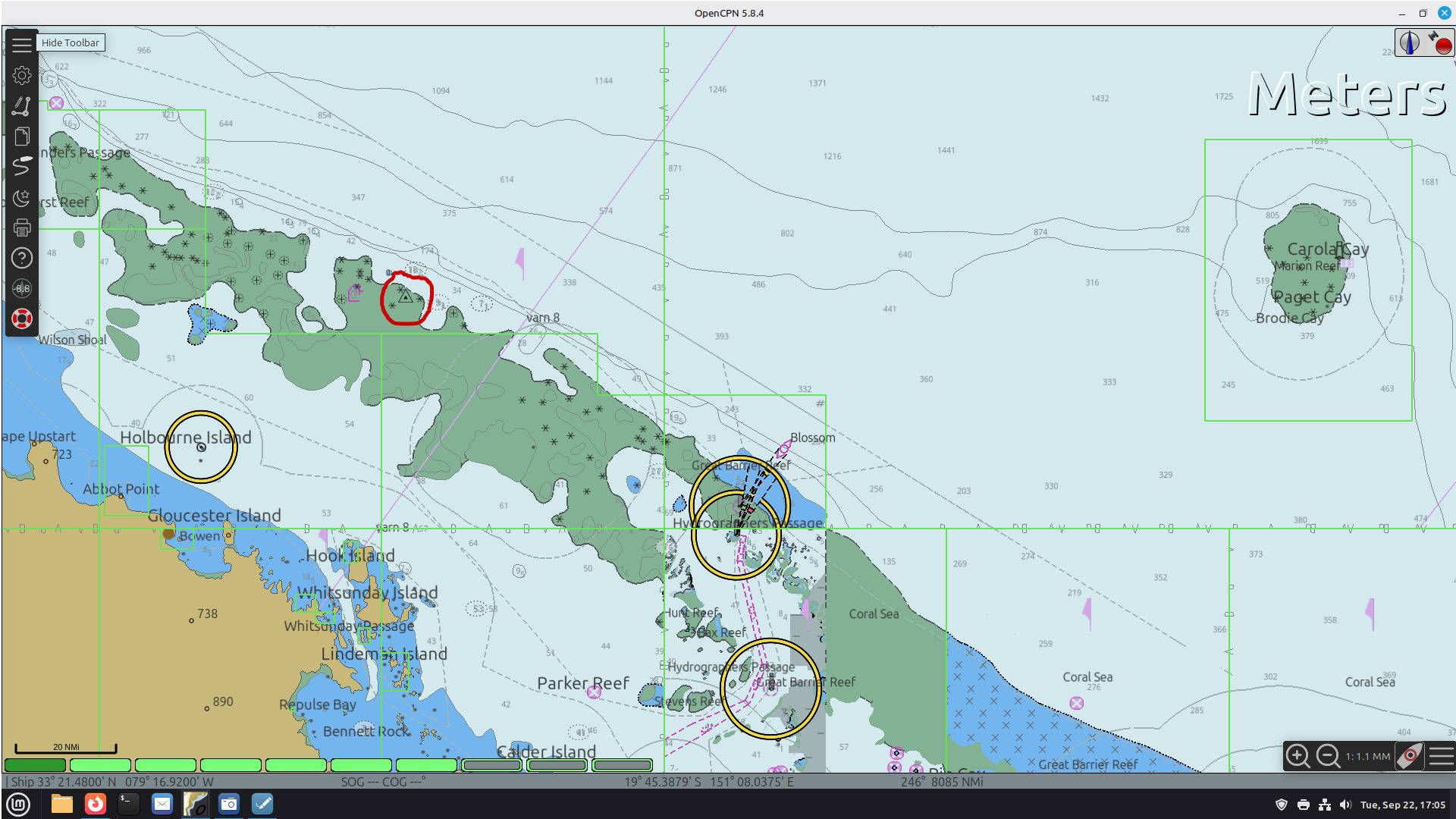
Well the OpenCPN screenshot I posted does show the area as a shoal not always covered by water. So if using OpenCPN for planning or sailing, you'd stay clear. The Navionics/Garmin chart doesn't show this (absent the satellite imagery) as the shallowest depth contour shown is 20m.

I note also the zone of confidence on the OpenCPN chart is U. That is "not assessed", arguably the least reliable. Reason to allow even more room from charted shoals/objects
Quixotic
Quixotic
ACT
260 posts
ACT, 260 posts
23 Sep 2026 2:44pm
Hi Gary.
Hope you’re not affected by Typhoon Dujuan.

Short answer is it’s a waypoint.

In OpenCPN I stuck a waypoint at the lat long to mark the location. As it is hard to see, I drew a red circle around it on the screenshot I posted (see
my first post in this thread). It shows the location as being in an area which is very shallow - see chart notes for location quoted in my second post.
Quixotic
Quixotic
ACT
260 posts
ACT, 260 posts
23 Sep 2026 11:23am
That is not reassuring in respect of Navionics (Garmin) chart.
The location (the triangle around a dot within the red circle) that I plotted on OpenCPN is at 19° 13.406' S 149° 05.050' E and shows it in area that is not always submerged. Certainly doesn't have a least depth contour of 20m(!)
Bringing up the summary chart notes on that location yields: "Obstruction (OBSTRN); foul area(6); shoaler than range of depth of the surrounding depth area; depth unknown(2); WATLEV covers and uncovers(4)"


Quixotic
Quixotic
ACT
260 posts
ACT, 260 posts
22 Sep 2026 5:11pm
If the LatLong on the AMSA video is about right, then it happened ~179NM West (271) of south end of Marion Reef/Paget Cay, about 51NM North (009) of Hook Island in the Whitsundays and 94NM East (086) of Cape Bowling Green.


Reply in Topic: Dodgy Rigging Split Pins
Quixotic
Quixotic
ACT
260 posts
ACT, 260 posts
27 Aug 2026 2:44pm
Just a guess, but might be the result of someone being interrupted during the work and thinking they'd already done that side, and not checking to make sure. Or the other classic is two people doing the work, being interrupted, and then one thinking the other one has already completed that bit, when they haven't, and again, not checking.

Whatever the reason, if it is not yet done, they need to spread the tails on those split pins. So I used the message the seller form alongside the ad to alert them to the apparent problem. If they respond at all, they may say the video was taken before the rigging work was finished.
Quixotic
Quixotic
ACT
260 posts
ACT, 260 posts
21 Aug 2026 10:30am
Where are you, interstate? If Southern Qld, then that's not too big a coastal sail from Pittwater, assuming the boat's seaworthy and properly equipped. Further afield is more challenging. Your profile says WA. That's no small expedition if that's where you want to take the boat. I suspect sailing is the only viable option financially, as by road will set you back tens of thousands to get to WA (at a guess maybe $50,000). Would likely make more sense to sell her in Pittwater and buy another in WA. A delivery skipper will generally charge perhaps $8-10 per nautical mile plus transfer costs (airfares taxis/ubers/bus and any accommodation needed). It's around 2300NM from Sydney to Fremantle, so if you hire one to go to WA, that may set you back between 20 and 30 thousand, add in a crew member as well and you'll be up for more. Another consideration is equipment. Do you have a tender and a liferaft in service? Also if you are in WA, I'd have thought it's a non-trivial cost to come back and forth to Pittwater to practice sailing every month or so, unless you'll be making the trip for other reasons as well. So a hard headed approach might suggest selling her and buying a boat where you now live. If it's adventure you want, you have the resources, and the boat's fit for purpose, then sailing her there's an option, provided you can get enough competent help.